Classifier
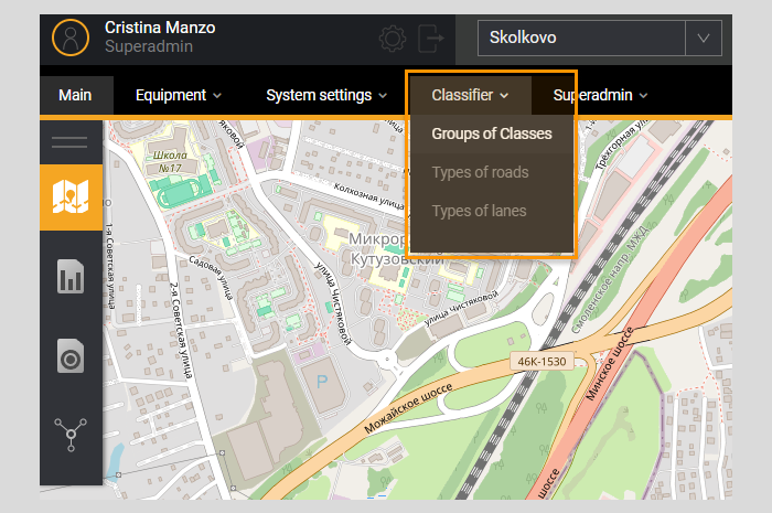
Menu item Classifier is intended for determination in the classification system of registered objects. The user has access to a filter for searching information and a list of class groups already added to the System.
The filter allows you to search for groups of road feature classes in the list. Next to the list name Class Groups information about the total number of class groups in the System is displayed.
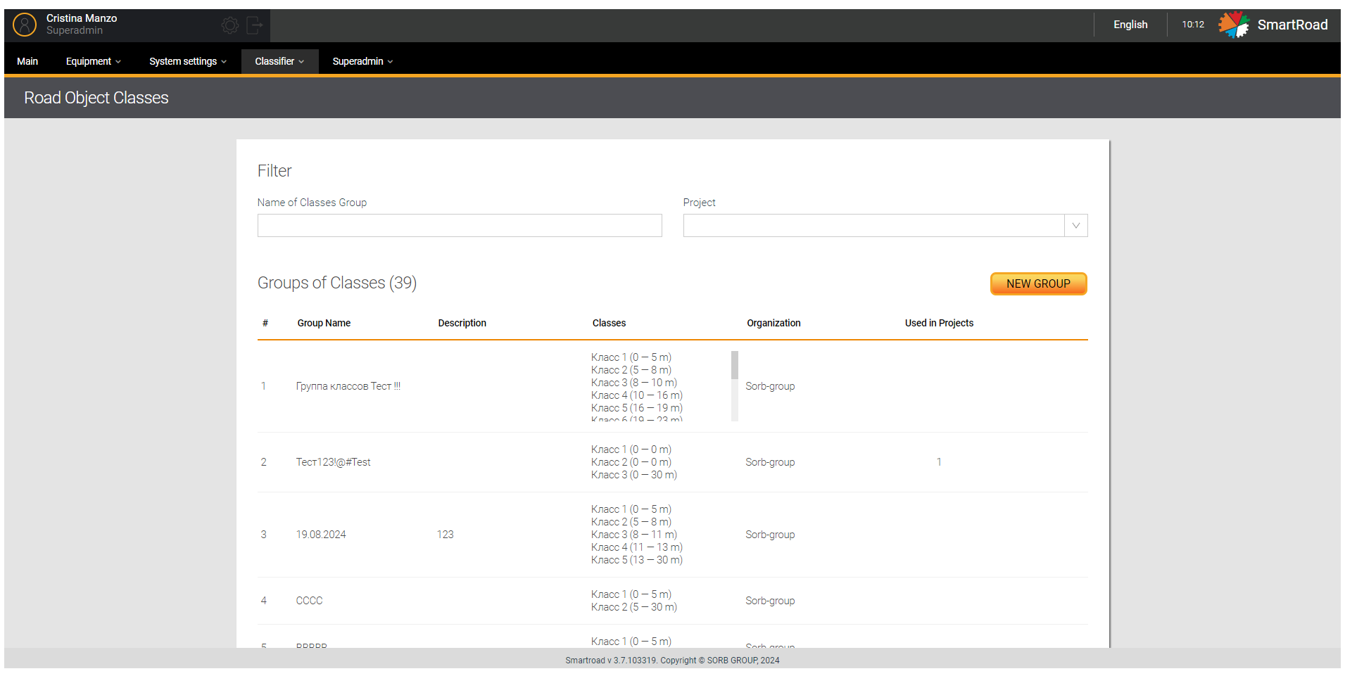
In the table below you can find the Class Groups filter parameters.
| Parameter | Description |
|---|---|
| Class group name | The name of the road feature class group is entered in the field |
| Project | In the drop-down list, the user is shown a list of projects registered in the System, to which class groups are attached |
Class groups created in the System are displayed in the list Groups of classes. The Parameters of the Class Groups list are indicated below.
| Parameter | Description |
|---|---|
| # | The serial number of the entry in the list |
| Group name | The name of the class group specified when adding |
| Description | Description of the class group specified when adding |
| Classes | Object classes included in a class group |
| Organization** | Organization to which the class group is associated |
| Used in projects | Number of projects that use a group of classes |
It is available only for users with the Superadmin role
Adding a new class group
The Classes are related to Road Object Classes
Adding a new group of classes is done using the button A new group. The user is shown a window for entering parameters for creating a new group by clicking on the button.
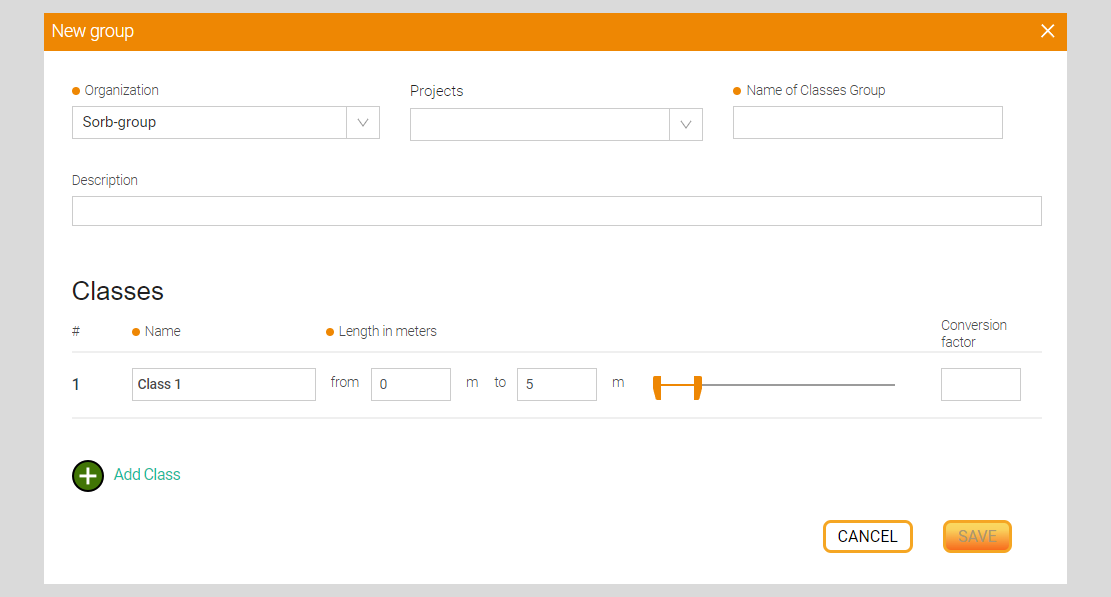
In next table are included the options for adding a class group.
| Parameter | Description |
|---|---|
| Organization*/** | In the drop-down list, the user is shown a list of organizations available for selection to which the class group will be associate |
| Projects | The drop-down list displays a list of available projects to which the class group will be attached. The choice is made by setting the checkbox |
| Class group name* | The name of the new class group is entered in the field, which will be displayed in the System |
| Description | A description of the class group is entered in the field. |
| # | Class number, the value is entered in the field automatically |
| Name* | The name of the class that will be displayed in the system |
| Length in meters* | Class length in meters. The values from and to are indicated. The user can set the length of class objects using the slider |
| Reduction coefficient | The number of passenger cars that corresponds to the vehicle in length |
| Add a class | Button to add a new class to a group |
| Save | A button that, by clicking on it the System saves the entered parameters and creates a new group of classes |
| Cancel | A button that, when clicked, resets the entered parameters |
(*) - It indicates that field is mandatory
(**) - It means that it is available only for users with the Superadmin role
Fields whose values are entered incorrectly will be highlighted in red. The values in them need to be changed, and the button Save in this case will be inactive.
Deleting and editing a class group
You must hover the mouse cursor over the entry in the list and click on the edit button to change the parameters of a class group. When you click this button, an editing window will open (similar to the adding window) with the previously specified parameters.
In case of removing a group of classes from the system, you must just click on the delete button. When you click on this button, you should confirm the deletion in a pop-up window by clicking the button Delete or cancel deletion by pressing the button Cancel.
Types of roads
Page Types of roads is intended for adding, editing and removing roads from the project. When you click on a menu item Types of roads you go to the road management page, on which there is a filter and a list of all roads existing in the System. The filter specifies the name of the road and the project to which it belongs.
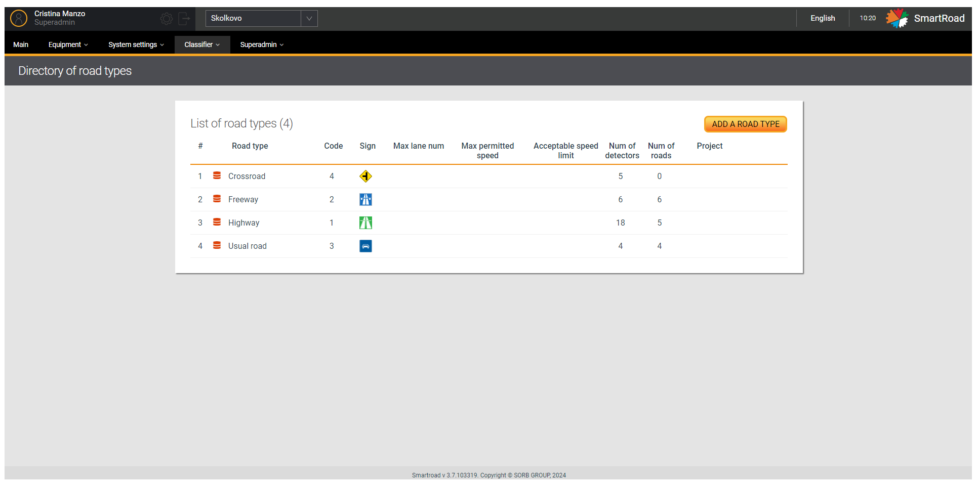
You should hover the mouse cursor over the entry in the list and click on the edit to change the strip type parameters. When you click the button, an editing window will open (similar to the adding window) with the previously specified parameters.
Besides, you must click on the delete button to delete a stripe type from the system. When you click on the button, you have to confirm the deletion in a pop-up window by clicking the button Delete or cancel deletion by pressing the button Cancel.
You can find the Road type list parameters in the next table
| Parameter | Description |
|---|---|
| # | The serial number of the entry in the list |
| Road type | The name of the road type specified when adding the road to the System |
| The code | Road type code |
| A sign | Image (icon) for road type |
| Max. number of lanes | Maximum number of lanes for road type |
| Max. permitted speed | Maximum permitted speed for road type |
| Non-penalized speed limit | Non-penalized speed limit for road type |
| Number of detectors | Number of detectors in the System whose settings use this type of road |
| Number of roads | Number of configured roads in the System that use this road type |
| Project | Name of the project in which the road type is used |
Adding a road type
Adding a new road type is done by clicking on the button Add road type. When you press this button, a window is displayed for entering parameters and adding a new road type.
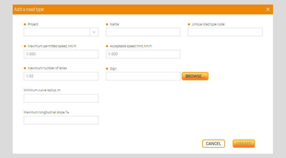
Furthermore, the Parameters for adding a new road type
| Parameter | Description |
|---|---|
| Project* | Drop-down list for selecting the project to which the new road type will be assigned. When you click on the field, the user is shown a list of projects available for selection |
| Name* | The name of the road type being created is entered in the field |
| Unique road code* | A unique code for the new road type is entered in the field |
| Maximum permitted speed, km/h* | The value of the maximum permitted speed (in km/h) on this type of road in km/h is entered in the field |
| Non-penalized speed limit, km/h * | The value of the non-penalized speed threshold (in km/h) on this type of road in km/h is entered in the field |
| Maximum number of lanes* | The value of the maximum number of lanes on this type of road is entered in the field (from 1 to 32) |
| Sign* | Pictogram for road type. When you click on the field, a window opens for selecting an icon file on the user’s PC. Once selected, the field displays the file path and file name. When you hover your mouse over the field, a tooltip with valid file parameters is displayed: - The size should not exceed: 100 kilobytes - File type: gif, png, jpg, jpeg, webp - Width and height no more than: 25px. |
| Review | A button that, when clicked, opens a window for selecting an icon file on the user’s PC |
| Minimum curve radius in plan, m | The value of the smallest curve radius in plan (in meters) for this type of road is entered in the field. This value is used in algorithms for determining events and incidents based on indirect signs in control zones where there is no direct detector coverage (between DT detection zones). The radius at which safe movement of the vehicle at the design speed with a clean, moistened surface, with the device of turns and widening the roadway. |
| Maximum longitudinal slope (%) | The value of the greatest longitudinal slope (in ppm on this type of road is entered in the field. This value is used in algorithms for determining events and incidents based on indirect signs in control zones where there is no direct detector coverage (between DT detection zones) |
| Create/Save() | When you click on the button, a new type of road is created in the System |
| Cancel | By clicking the button, the Add road type window closes, the System returns the user to the List of road types page |
(*) - These are required fields
Fields whose values are entered incorrectly will be highlighted in red. The values in them need to be changed. In this case, the button Create will be inactive.
Types of lanes
The user can create, edit and delete new types of lanes in the System in the pages Types of lanes. When you click on a menu item Types of lanes the page goes to Directory of lanes types, which contains a list of all lanes already added to the System.
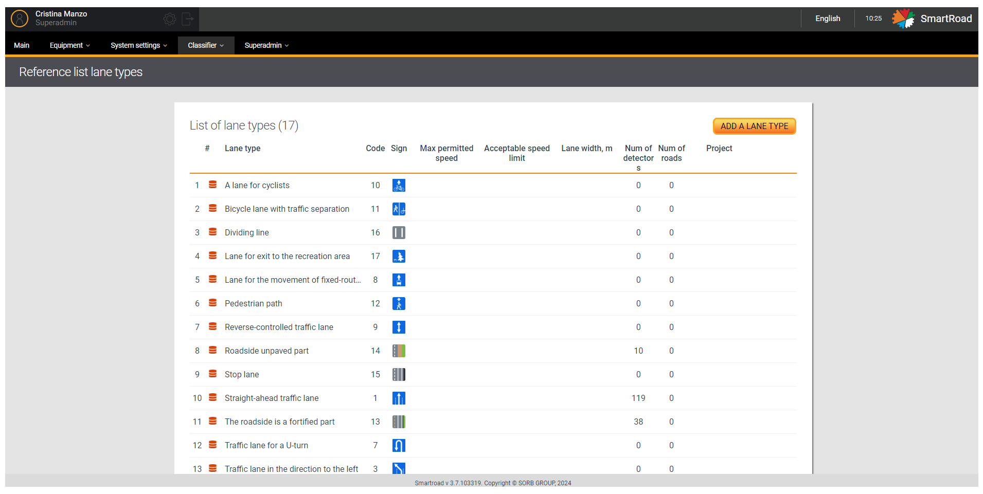
The land type list parameters are described in the next table
| Parameter | Description |
|---|---|
| # | The serial number of the entry in the list |
| Band type | Band type name |
| The code | Band type code |
| A sign | Images (icon) for stripe type |
| Maximum permitted speed | Maximum permitted speed for lane type |
| Non-penalized speed limit | Non-penalized speed threshold for lane type |
| Lane width, meters | The width of this type of strip, indicated in meters |
| Number of detectors | Number of detectors in the System whose settings use this type of band |
| Number of roads | Number of configured roads in the System that use this lane type |
| Project | Project in which the strip type is applied |
You should hover the mouse cursor over the entry in the list and click on the edit button to change the lane type parameters. When you click the button, an editing window will open (similar to the adding window) with the previously specified parameters.
You have to click on the delete button to delete a lane type from the system. When you click on this button, you must confirm the deletion in a pop-up window by clicking the button Delete or cancel deletion by pressing the button Cancel.
Adding a lane type
Adding a new lane type is done by clicking on the button Add a lane type. When you press the button a window is displayed for entering parameters for adding a new stripe type.
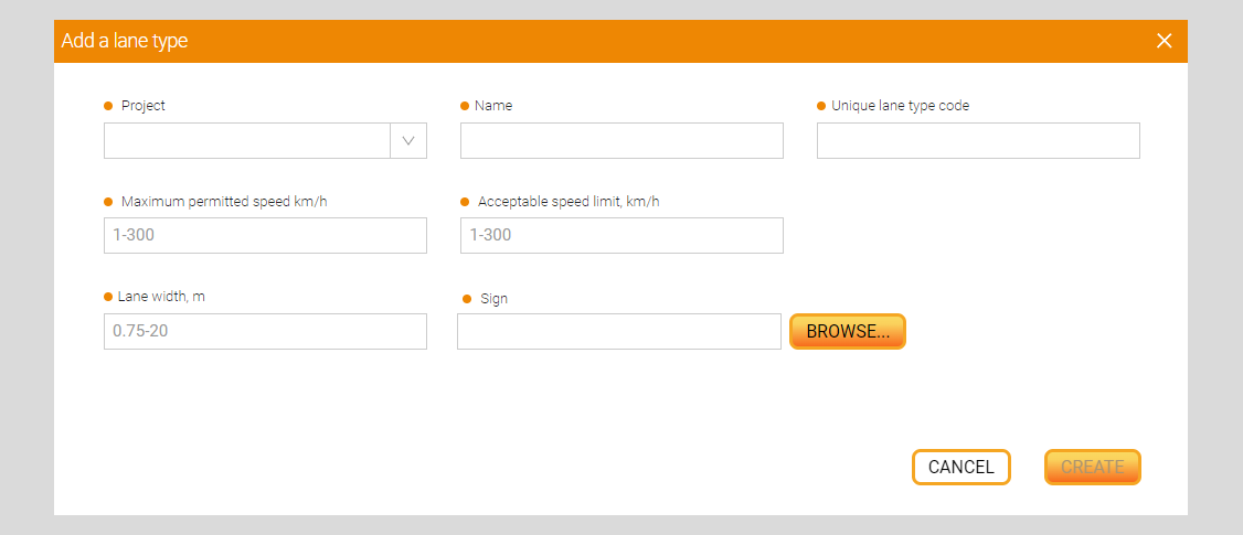
In the table below the Options for adding a new lane type
| Parameter | Description |
|---|---|
| Project* | Drop-down list for selecting the project to which the new strip type will be assigned. By clicking on the field, the user is shown a list of projects available for selection. |
| Name* | The name of the stripe type to be created is entered in the field |
| Unique band code* | A unique code for the new stripe type is entered in the field |
| Maximum permitted speed, km/h * | The value of the maximum permitted speed (in km/h) for this type of lane in km/h is entered in the field |
| Non-penalized speed limit, km/h * | The value of the non-penalized speed threshold (in km/h) for this type of lane in km/h is entered in the field |
| Lane width, m * | Enter the width of this type of strip in meters in the field |
| Sign * | Icon for stripe type. When you click on the field, a window opens for selecting an icon file on the user’s PC. Once selected, the field displays the file path and file name. When you hover your mouse over the field, a tooltip with valid file parameters is displayed: - The size should not exceed: 100 kilobytes - File type: gif, png, jpg, jpeg, webp - Width and height no more than: 25px |
| Review | A button that, when clicked, opens a window for selecting a icon file on the user’s PC |
| Create | Clicking on the button creates a new type of strip in the System |
| Cancel | By clicking on the button, the Add lane type window closes, the System returns the user to the List of lane types page |
(*) - These are required fields
Required fields whose values are entered incorrectly will be highlighted in
red. The values in them need to be changed. In this case, theCreatebutton will be inactive.